I’ve been watching this forum for months, and I keep seeing the same pattern over and over. People bragging about buying parcels they found on some auction site or through a wholesaler, sight unseen, because “the numbers looked good” or “it was such a steal.”
Then three months later: “Help! My land is in a flood zone!” or “There’s no legal access!” or my personal favorite, “Turns out it’s a wetland and I can’t build anything.”
I get it. We all want to grow quickly. But this spray-and-pray approach is going to burn so many of you. I can tell you that the investors who consistently make money are the ones who do their homework.
Yes, it takes longer. Yes, you’ll pass on deals that might have worked out. But you’ll also avoid the disasters that wipe out your profits for the next two years.
If you haven’t physically walked a property or at least had boots-on-ground verification, you’re not investing, you’re gambling. And the house always wins in gambling.
Call me old school, but I’d rather buy one good piece of dirt a year that I actually understand than ten “deals” that might blow up in my face.
Who’s with me on this? Or am I just being paranoid?
@sallyhoskins I think what you are describing is buying a property with no due diligence whatsoever? I agree that’s a recipe for disaster, but I don’t hear of many people doing that.
On the flip side, I think most of us get into this business with the dream of “freedom of location” in mind. The online tools available nowadays for remote research are insane. That being said, I think you almost have to do dispo through realtors in some way or another so you can at least have boots on the ground. I think it’s a necessity to make that dream a reality and well worth the commission to help you avoid major headaches. Not necessary for every market, but most I think.
I agree you need to do your due diligence on each property, most of which can be done online or by calling county offices. If you just buy a property solely on price that’s surely going to backfire.
As far as boots on the ground, after we have a property under contract we send a drone pilot our for aerial/ ground photos and videos and they also give us a written report on things like the road condition, neighboring properties etc that’s helpful. If the results are unsatisfactory we don’t continue with the purchase. So far we’ve had two properties that really differed from what we found ourselves, one had unmanaged roads which then blocked access to our lot and a second was swampy despite the systems we use saying it wasn’t.
Even with all that you still might end up with surprises such as grumpy neighbors who maybe missed the drone pilot. We had a neighbor chase away our realtor and two potential buyers with a machete. While that deal was lost thankfully the realtor got the guy under control and we had actually a better offer come around the next week.
@Nicole This is GOLD! I am newer to the space and you always hear people talk about drones for disposition photos, but using it to kill 2 birds with one stone to do due diligence and at the same time take photos for the listing makes complete sense. Thanks so much for this tip!
We’ve been funding deals for 4 years, many without having a trusted person see the land.
Yes, it’s definitely speculating. We try not to be gamblers. But sometimes…
You can say you “like” Tennessee. But there are many different areas. Knoxville is not Nashville. I just did an 11 day road trip looking at mistakes we made. Most could have been avoided if we used online tools better. But some, oh boy! Did we miss stuff!
Totally with you on this. Rushing into deals without proper due diligence is risky and often ends in regret. It’s not paranoid—it’s smart investing. Better one solid deal than ten potential disasters.
I just spent 10 days driving to see mistakes we made in our virtual land flipping biz. Almost all were avoidable if someone stood on the property. Most of our failures are slope issues. We didn’t understand topography via Google Earth or Land.ID well enough. So we think we are OK on most but really really are going to push for the chosen agent to walk property and report with pictures and video on deals over $100k. Still flipping low value desert squares sight unseen.
One of the biggest issues almost everyone makes is not finding out about old oil and gas activity on land. Plugged wells are cut-off below ground so you will visually not see them. Also, many mapping sites do not provide all of the wells that are known and the locations are usually off because lat/long was not used when these wells were drilled. Finally, all plugs will fail at some point.
I am not saying to avoid properties with old oil and gas activity, but you need to know much more detail about the potential issues than what is currently done. Even a Phase 1 does not provide you with the information you need.
@JB_Scott, what would you say is the easiest or most efficient way to uncover this information? @Vernon_Henry talked a bit about this when I interviewed him in episode 227, but I’m curious to hear how you would do it.
@retipsterseth I did a quick review of your talk on episode 227, and I was impressed with Vernon’s knowledge and work regarding mineral title work. However, I am talking about something that is different but it relates to your comment to Vernon about an old mine shaft on property.
For over 25 years, I owned an oil and gas service business that dealt with drill cuttings - the solid waste that comes up from the wellbore when you drill the well. I then took this knowledge and data and combined it with detailed research on why plugs fail. The result is a property report we generate that provides detailed information on each well on a property including active, inactive, and plugged wells. The report also includes a well-specific risk score on potential for plugged wells to fail and a risk score on buried drilling waste.
Even though someone could gather information on wells from the state regulator, they would have a very difficult time in understanding what they are looking for and then at and they would not have the knowledge to determine the risks of plugged well failures or of drilling waste risks.
The point of the reports is to understand the risks on a property and how to manage them.
I am sure that many people will think this only applies to areas like Texas or California. However, at least 43 states in the Lower 48 have had oil and gas wells drilled in them. For example, Illinois, Kentucky, Kansas, Florida, Ohio, Michigan, etc.
No one should ever buy a property without this knowledge.
If you are interested, I would be glad to discuss this in more detail.
@JB_Scott, that’s super interesting. I wonder, are there any red flags you could look for on a property to tip you off on whether this might be a problem?
And how common of an issue is this? For example, if there are 100 million individual parcels of land across the entire United States, what percentage of those do you think realistically have this issue on them? Does this affect 5% of them? Or maybe 1%? Or much lower, like 0.000001% of all parcels?
Just trying to get a realistic idea for the likelihood of encountering this.
@retipsterseth, one red flag is if there is visible oil and gas production in the area and another red flag is if there is an oil and gas lease mentioned at any time, active or not, in the title work.
Approximately, 4 million wells have been drilled in the US and of these, about 1.7 million have been plugged. The vast majority of the remaining wells produce very little and are often idle. The operator just produces them so they don’t have to pay to plug. They are also a real concern.
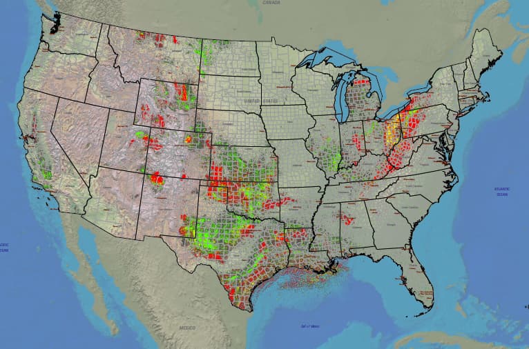
Of the 3,144 counties in the US, 1,673 counties have at least one well drilled in them. This means about 53% of the total counties have had a well drilled.
The USGS map below from 2007 shows the wells. More have been drilled since then. If you could zoom in, you could see them in places like Florida where people don’t think this is an issue.
@JB_Scott that’s a great map! Super helpful. Where did you find that thing? Is there a more interactive, zoomable map somewhere we can use to inspect this closer?
@Steve_Hodgdon you might want to check out The Land Portal and their slope reports. They are insanely accurate. I invested close to home even though it wasn’t a very good market for the sole reason of being able to drive to properties and see them in person. I made some bad decisions early on related to slope and they became very evident when I went to walk the property in person.
I recently signed up with The Land Portal and went back and plugged some of these properties into their slope analysis report and it absolutely nailed the topography on all of them. We are talking about showing a 1000 square foot flat pad on a 2 acre fully sloped property. I was speechless. This tool is amazing at analyzing true buildable area on a sloped property.
That in combination with drone photos after purchase has helped my due diligence process quite a bit.
It’s a good point about Land Portal’s slope reports. They’re great. I’ve actually got a whole blog post and video that explains why they’re so useful.
Keep in mind, it’s not just about evaluating a single property. You can also filter your entire list to include/exclude properties that fit whatever slope profile you’re looking for.
Totally agree. I learned the hard way, bought a parcel sight unseen, and it ended up with no legal access. Never again. Walking the land first saves a lot of headaches.